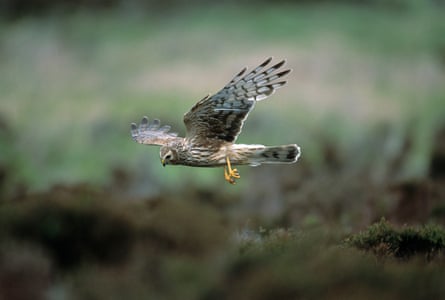
A grey male drifts slowly across the moorland. No, not me, but a big, beautiful hen harrier, scouting for love, or breakfast. I’ve only been here 10 minutes, and I’m in a mild state of shock. Aren’t these precious, threatened birds of prey so vanishingly rare that seeing one is hugely improbable?
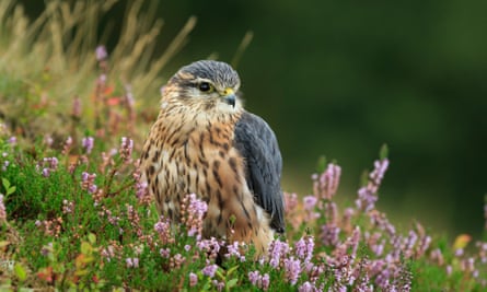
I’m walking with Sonja Ludwig, RSPB species and habitats officer for the Forest of Bowland, and she knows these harriers. “They’re ‘traditional’ birds,” she says. “They tend to come back to more or less the same place. We always see them here. Rookies always notice the males first. Their plumage, white rump and the black tips on the wings are unmistakable.”
Hen harriers are sometimes nicknamed “grey ghosts” or “ghosts of the moor”. When I spot a second male above the moor top, I’m delighted. “Now you have to try to find the female,” says Ludwig.
We scan some more and, remarkably, after just a few minutes, there she is, brown and white, all striations and streaks – and an owlish face when seen from the front.
“I’ve got them well trained, haven’t I?” says Ludwig.
I won’t share a grid reference. Hen harriers – the most persecuted bird of prey in these islands – need peace and security, especially in spring, when they pair up, nest and rear chicks. The key point is, if you want to see them, they’re right here. As Ludwig puts it: “Bowland takes a bit of effort. Hillwalkers like it, but it’s not really the kind of place where you roll up in a car and light a portable barbecue by the roadside.”
The Forest of Bowland intrigues me. I see it every morning from the kitchen, having relocated to an area just outside the national landscape (formerly known as an area of outstanding natural beauty) four years ago. I drive through it to get to Lancaster when the M6 is jammed, and sometimes motor along its edges en route to the Yorkshire Dales or Lake District, the two national parks on either side of Bowland. But I don’t go there often, and I’m not alone – it’s probably the most overlooked, bypassed rural landscape in the north of England. The Lakes get 18 million visitors a year, the Dales more than 6.5 million; Bowland doesn’t record visitor numbers, but historically it was in the tens of thousands – despite being just north of densely populated east Lancashire and close to Preston and Blackpool.
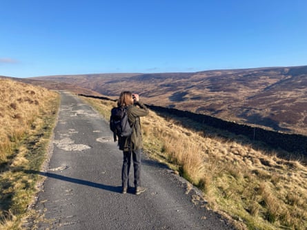
There’s something mysterious about this landscape. Formed by ancient seas, glaciation and erosion, and shaped by wet and windy weather, the Bowland Fells look like a cross between moorland and mountain massif. They are covered in heather and blanket bog, not particularly shapely, and the highest point, Ward’s Stone, is a mere 561 metres (1,841ft) above sea level. Pendle Hill, an outlier of the national landscape, is more handsome than any of the fells.
Walking along the higher paths is a bit like being on a raised steppe, barren-looking and exposed to the elements. When artist Rob St John, who is developing a series of installations for the national landscape under the title Are You Lost?, asked local people who didn’t routinely visit the area what they imagined it was like, their answers were often along the lines of “bleak”, “scary” and “cold”.
Access is a challenge. The north-south Bentham to Chatburn road takes a highish line through agricultural areas. More dramatic – and trafficked – is the winding, diagonal road through the Trough of Bowland, the geological feature of the region that many know. Other roads skirt Bowland or suddenly peter out into motorbike/walking tracks, as happens with the Roman road between Slaidburn and Hornby. Parking is limited and bus services few – though the number 11 bus, launched a year ago, has been a huge success, connecting some of the most scenic spots with Clitheroe and Settle, which have railway stations.
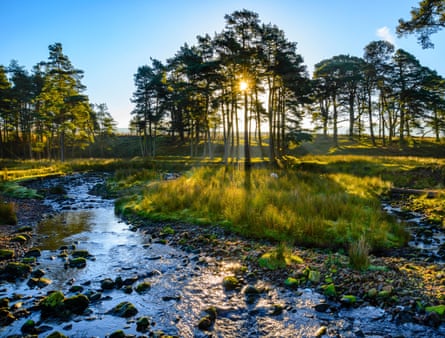
In September 2004, much of Bowland was opened up to walkers for the first time when the Countryside and Rights of Way Act 2000 gave general right of access to the public to “access land” for the purposes of open-air recreation on foot. But people can only walk, run and – where permitted – ride bikes where there are paths. Many of Bowland’s upland areas are boggy and only the hardy, or foolhardy, would want to negotiate steep-sided cloughs (valleys) and slopes cloaked in knee-deep heather, riven by deep gullies.
But limited access and smallish visitor numbers bring benefits for nature. A large central section of the 775 sq km (300 sq miles) of the national landscape is designated as a site of special scientific interest because of the habitats it protects and its internationally important bird populations, particularly the hen harrier and merlin. The latter is the UK’s smallest bird of prey, about the size of a thrush. I probably wouldn’t have spotted one during my visit if Ludwig didn’t know where to look. With binoculars, we could just identify a greyish dot seated – pointedly – on top of an old grouse butt.
As I was focusing, another bird flashed across the valley where we were seated. It was a male peregrine falcon, apparently returning to a nesting area where a female was either incubating eggs or readying the site to lay them. I had never seen a peregrine before, though I had seen their food refuse in urban areas. To watch the fastest bird in the world – capable of 240mph during a hunting dive – slowing down to salute its mate was special.
While looking out for the birds of prey, I saw plenty of other species: meadow pipits, skylarks, curlews, a stonechat, a greylag goose. The star turn was a couple of ring ouzels – a red-listed (meaning “of high conservation concern”) member of the thrush family that dwells on the uplands. As spring rolls on, keen-eyed birders will see, in the reedbeds and on heathlands, pied flycatcher, redstart, wood warbler, lapwing and rare black grouse – plus common sandpiper and dipper down on the riverbanks. Bowland also supports a large colony of lesser black-backed gull, for which the UK is an internationally important territory.
Parts of Bowland are used for driven grouse shooting between August and December. A divisive pastime, it arouses passions among conservationists. Every year raptors are illegally killed in areas where shoots are frequent, and in late 2024 one of Bowland’s female hen harriers disappeared “in suspicious circumstances”, despite being fitted with a satellite tag. While Bowland has a long history as a hunting area – the ancient word “forest” refers to a royal hunting ground rather than tree cover – the grouse-hunting business began in the middle of the 19th century. It is the management of the fells for the rearing of the shooters’ targets – little red grouse, whose bubbling calls I heard often as we walked – that has shaped the Bowland we see today.
But JMW Turner’s sketches of the Trough and other areas, from 1816 – pre-dating modern moorland management – show bare-topped fells and only a few native trees on the becks and lowest slopes. In fact, most upland trees were probably felled when agriculture arrived thousands of years ago, and the Normans didn’t require tree cover when they first created the hunting grounds for deer.
What Bowland offers is not gushing beauty, photogenic peaks or well-trodden footpaths, but moments of wildness in a man-made (the gender is not accidental) landscape. Visiting it, as well as a simple joy in itself, is a way of staking a claim on behalf of the region’s most vulnerable inhabitants – the raptors.
The “summit” of my mini-safari with Ludwig was when the male hen harrier began to perform what is known as a sky dance. Against a big, clear-blue backdrop and above a patch of chocolate-coloured heather where a female lurked, he shot upwards and began to pirouette, and then fall, and then flip, and twist and, frankly, show off like billyo – to impress her, to warn younger males to stay away and, perhaps, because flying like that must feel just ace.
Download walks and cycling routes here. The Eco Escapes guide has suggestions for car-free visits, while the latest official Discover Bowland guide has a feature on all-terrain wheelchair walks