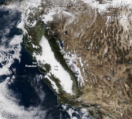
New Nasa satellite images reveal the scope of central California’s dreary December, caused by an enormous fog formation that has been haunting the Central Valley for weeks, trapping residents in colder-than-usual temperatures.
The low cloud formation, known as tule fog, first formed over central California in November and persisted into early December. The Central Valley typically sees this type of fog during the colder months of the year, when the air near the ground is cold and moist, and the winds are calmer, allowing moisture in the air to transform into a thick layer of fog.
As the cold blanket of fog forms, it becomes trapped in the bowl-like shape of the Central Valley. The warmer temperatures of the air above keep the fog stuck in the valley like a lid over a pot, also known as temperature inversion.
As seen in Nasa’s imagery, the tule fog remains steady over the Central Valley, moving through the Carquinez Strait in December, toward the San Francisco Bay.
The tule fog crept in after a major storm hit California in late October, which caused “the worst severe thunderstorm outbreak over the central California interior in recent memory”, the National Oceanic and Atmospheric Administration said in a report.
The National Weather Service has issued several dense fog advisories in central California’s Foothill region over the past week due to the lingering tule fog, which impacted visibility on mountain roads, which could see “sudden drops in visibility to less than 1/4 mile” until Saturday at 11 am.
The lingering tule fog has contributed to the chillier conditions locals report feeling in central California and the Bay Area. The Central Valley has experienced an average low temperature of 37F and average high of 63F so far this month, with the Bay Area at 43F and 65F, respectively.
Drew Tuma, ABC 7 News meteorologist, writes that as the fog tries to move out of the valley, it seeps out into the Carquinez Strait, moving the tule fog into the Bay Area and lowering temperatures there, too.
While cool fog and tule fog are not uncommon in these regions at this time of year, climate scientist Daniel Swain of the California Institute for Water Resources says warmer overall conditions are making this persisting fog persist.
In his climate blog, Weather West, Swain writes that the warm ocean water offshore and the lack of snowpack in the Sierra Nevadas has led to “relatively warmer surface temperatures”, which is causing the inversion and preventing the fog from lifting.
Carlos Molina, a National Weather Service meteorologist in Hanford, told the Los Angeles Times that tule fog typically lasts about a week, putting this two-week-long blanket more “on the extreme side”.