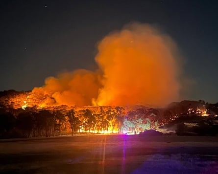
Dire bushfire conditions threatened south-eastern states on Friday as unrelenting heat bore down on large parts of Australia and Victorians prepared for catastrophic conditions not seen since 2019-20.
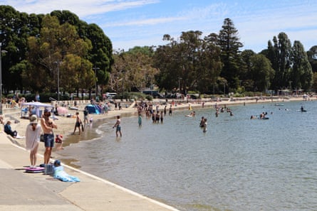
Melbourne’s maximum temperature was forecast to reach 43C on Friday, and up to 45C in some suburbs. The city was 38.7C at midday and reached 40C by 1pm.
Anthony Albanese met with officials in Canberra for a briefing on the extreme conditions and said these were “difficult times” for the country.
The prime minister urged people to listen to advice from the authorities, if asked to leave properties in the path of a bushfire or advised not to risk driving in floodwaters.
“We hope for the best but we prepare for the worst,” he said.
Catastrophic and extreme fire danger ratings were in place throughout Victoria, with the entire state under a total fire ban. The central district, which includes Melbourne and Geelong, was approaching catastrophic with a fire danger rating of 99 (100 or more is considered catastrophic).
Fires were expected to be “unpredictable, uncontrollable and fast-moving”, Victoria’s emergency management commissioner, Tim Wiebusch, said as the extreme heat combined with damaging winds and the risk of dry lightning.
Extreme conditions were also expected across much of South Australia as well as the New South Wales Riverina. Heatwave warnings remained in place for all states and territories except Queensland.
Walpeup, in north-west Victoria, hit 44C just before lunch , while 44.9C was recorded at Renmark airport, SA .
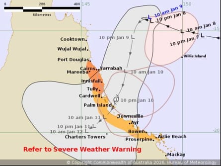
In Queensland, a tropical low heading towards Cairns was forecast to intensify into a tropical cyclone Koji by the time it made landfall.
Sign up: AU Breaking News email
The Victorian premier Jacinta Allan said it was “the most dangerous day we have had in years”, with fire crews battling blazes in some of the “toughest conditions imaginable”.
Fires were already burning in several states, including out-of-control bushfires at Longwood and Walwa in Victoria.
The chief officer of the CFA, Jason Heffernan, warned conditions on Friday would be “dire”, including potential wind gusts of up to 100km/h.
“Do not travel today if you don’t need to,” he said.
A total fire ban was in place across the entire state of Victoria, 11 out of 15 fire districts in South Australia and four in NSW (eastern and southern Riverina, Monaro Alpine and Southern Slopes).
Wind gusts of 96km/h were recorded at Mount Gellibrand, east of Colac at midday.
The Bureau of Meteorology was forecasting daytime temperatures 12-16C above average across much of south-eastern Australia.
Sydney could expect the worst of the weather on Saturday, Scully said, with temperatures forecast to reach 42C and extreme fire danger extending statewide.
On Thursday, many places recorded their hottest January temperature on record, said Sarah Scully, a senior meteorologist at the bureau. They included Renmark, which reached 47.3C, and Loxton at 46.2C, both towns in SA’s Riverland, as well as Hopetoun (46.3C) in Victoria’s Mallee.
Tarcoola, in SA’s far north, reached 48.2C on Thursday.
There was little relief for people in heatwave affected areas after days of extreme daytime temperaturesturning into warm nights. Renmark’s minimum overnight was 30.9C.
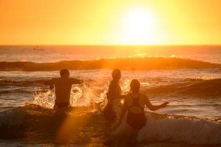
“People need to take action to stay cool, hydrated and stay indoors where possible,” Scully said.
What happens to the body during a heatwave?
ShowHeatwaves put intense stress on the body - particularly the cardiovascular system and kidneys. The heart has to work hard to deliver oxygen and nutrients to organs while also increasing blood flow to extremities. Cardiovascular collapse – the heart suddenly failing – is a main cause of heat-related death in Australia.
Symptoms to watch out for:
- Hot skin
- Confusion
- Weakness
- Cramps
- Dizziness
- Vomiting
- Fainting
In Victoria, a section of the Hume Highway remained closed, public land and parks were closed, and several regional train and coach services cancelled.
In Melbourne, Metro Trains advised delays were likely across the city’s entire rail network.
A number of post offices in catastrophic risk zones were expected to close this afternoon, with delivery delays expected due to bushfires.
Capital city forecast for Friday:
-
Melbourne: Windy. Late cool change, possible storm, maximum 43C.
-
Canberra: sunny, maximum 39C.
-
Adelaide: mostly sunny, maximum 32C.
-
Sydney: sunny, maximum 33C.
-
Darwin: showers, storm, maximum 33C.
-
Perth: partly cloudy, maximum 29C.
-
Brisbane: possible shower, maximum 29C.
-
Hobart: shower or two, maximum 25C.
A cool change was expected to move through south-western Victoria in the early afternoon, reaching Melbourne between 6pm and 7pm.
Tasmania was also expecting elevated fire risk, with the Tasmania Fire Service declaring a total fire ban for the state’s south and the Furneaux Islands from Saturday. ACT has also declared a total fire ban for tomorrow.
It has been unusual to have such extreme heat and fire conditions during a La Niña summer, and after a strong negative Indian Ocean Dipole, according to Andrew Watkins, a climate expert at Monash University.
“Normally we would be more worried about floods with those climate drivers,” he said. “But two factors have played a big role in 2025/26, including the strongest stratospheric warming above Antarctica since 2019, and climate change.”
As of 11am on Friday Queensland’s tropical low was about 65km from the coast, with sustained winds of 65km/h and gusts up to 95km/h.
The system was expected to take a sharp turn southwards today, heading for Townsville.
A warning zone stretched from Port Douglas to Tully, including Cairns and Innisfail.
Australia experienced its fourth-warmest year on record in 2025, with average temperatures up 1.23C nationally, according to BoM.
The climate crisis has increased the frequency and severity of extreme weather events, including heatwaves and bushfires.